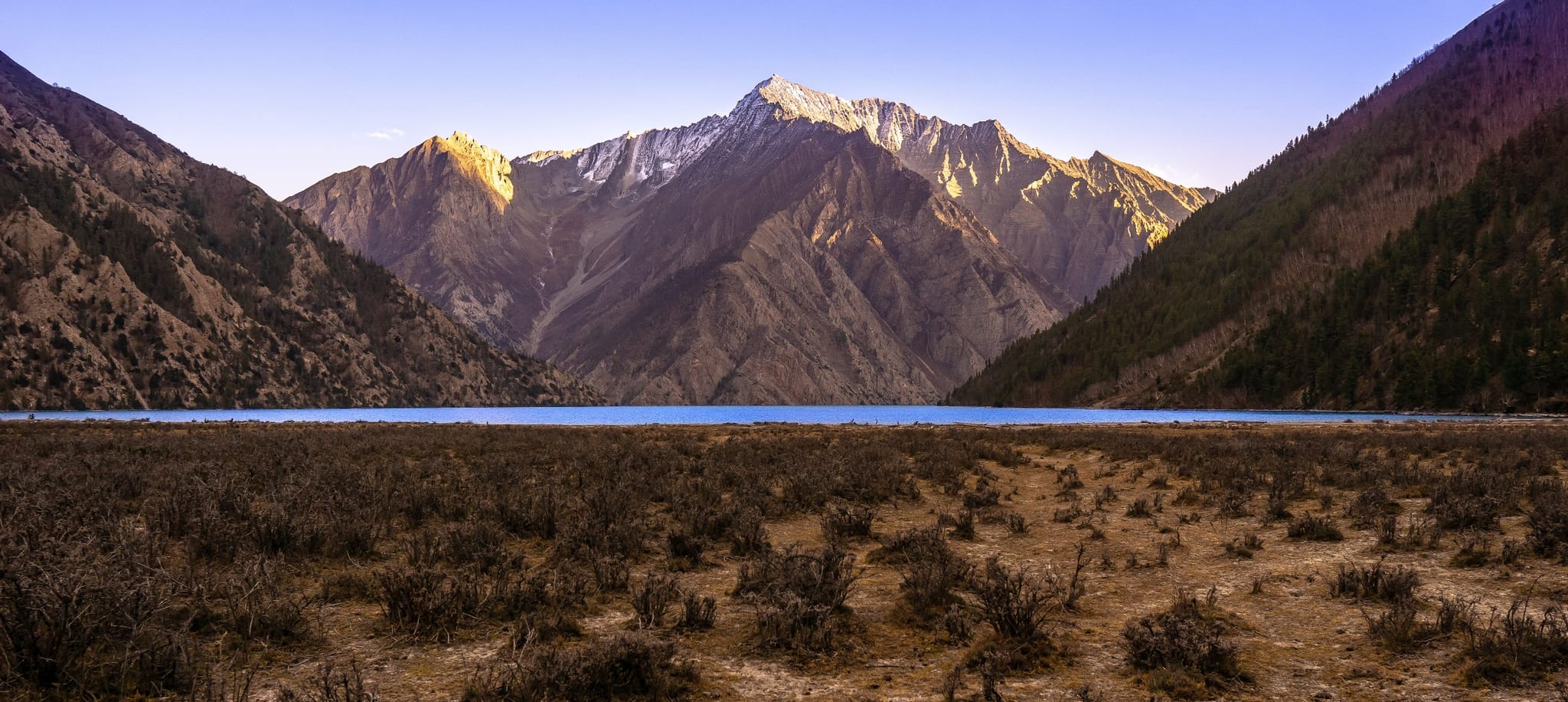
Upper Dolpo
Beyond the familiar trails, into the ancient valleys of Dolpo.
Trip Overview
- Best season
- Spring · Summer · Autumn
- Group size
- 2 – 8 People
- Start & end
- Kathmandu
Highlights
- Shey Phoksundo Lake **Visit one of Nepal’s most striking high-altitude lakes, known for its blue-green water and dramatic mountain setting near Ringmo village.
- Shey Gompa and Crystal Mountain Explore the spiritual heart of Upper Dolpo, where Buddhist traditions and the sacred landscape around Crystal Mountain are central to local culture.
- High Himalayan Passes Cross remote passes such as Kang La, Shey La/Saldang La and Jeng La, subject to the final route and conditions.
- Traditional Dolpo Villages Walk through settlements such as Namgung, Saldang, Sibu and Dho Tarap, with stone houses, fields and distinctive local architecture.
- Historic Trans-Himalayan Trails Follow paths associated with trade and movement between Dolpo and Tibet.
- Changing Landscapes Travel from forested river valleys and Phoksundo’s lakeside cliffs to high, dry plateaus, rocky passes and the broad Tarap Valley.
- A Remote Camping Expedition Experience a part of Nepal where facilities remain limited and careful planning, local knowledge and self-sufficiency are essential.
- Traditional Dolpo Villages Walk through settlements such as Namgung, Saldang, Sibu and Dho Tarap, with stone houses, fields and distinctive local architecture.
About this trek
The Upper Dolpo Trek is a demanding journey into one of Nepal’s most remote Himalayan regions, where high mountain passes, arid trans-Himalayan landscapes and traditional settlements preserve a distinctive cultural heritage. The route combines Shey Phoksundo Lake, the sacred landscape around Shey Gompa and Crystal Mountain, and villages such as Namgung, Saldang and Dho Tarap.
The trek normally begins with flights from Kathmandu to Nepalgunj and onward to Juphal, followed by a walk to Dunai and the trail towards Phoksundo Lake. From Ringmo, the route enters the upper valley and crosses Kang La to reach Shey Gompa. The journey continues through remote settlements and across high passes, including Shey La/Saldang La and Jeng La, before descending into the Tarap Valley and returning through lower Dolpo.
Upper Dolpo is not defined by mountain views alone. Its character comes from ancient trade routes, Tibetan Buddhist and Bon traditions, stone villages, cultivated fields and the daily lives of communities living in a demanding high-altitude environment. Much of the route has limited or no lodge accommodation, so a supported camping expedition is generally required.
This is a remote, strenuous trek with several passes around or above 5,000 m. It is best suited to experienced trekkers who are prepared for long walking days, cold nights, basic facilities and possible changes to the itinerary due to weather or trail conditions.
Join Junkiri Treks to explore Phoksundo Lake, visit Shey Gompa and walk through the ancient valleys and settlements of Upper Dolpo.
Day by Day Itinerary
Welcome to Nepal. Upon arrival at Tribhuvan International Airport, our representative will meet you and transfer you to your hotel. The rest of the day is free to rest or explore the surrounding area.
Today is reserved for final preparations. Your guide will review the itinerary, check personal equipment, discuss restricted-area documentation and explain the camping arrangements. Optional sightseeing or cooking class may be possible if time allows.
Take a domestic flight from Kathmandu to Nepalgunj in western Nepal. The climate is warmer than Kathmandu, and the town is the staging point for the flight to Juphal. Use the afternoon to confirm baggage arrangements and prepare for an early departure.
Take the flight to Juphal, the principal air gateway for the classic Dolpo trekking route. From the airstrip, walk towards Dunai, following the trail into the Bheri River valley. Meet the local crew and organise equipment for the expedition.
Begin the trekking section by following the Suli Gad valley towards Shey Phoksundo National Park. The trail passes small settlements, river crossings and forested slopes. Walking is steady, with repeated ups and downs.
Continue upstream through forest, crossing bridges and following the valley towards Phoksundo Lake. The route can be uneven and steep in places. The crew will select a suitable campsite according to water availability, walking pace and local conditions.
Climb through forested terrain towards Ringmo, the traditional village near Phoksundo Lake. The lake’s blue-green water and dramatic mountain backdrop create one of the most memorable settings in western Nepal. Settle into camp and explore the village if time permits.
Spend an additional night in the Phoksundo area to support acclimatisation before climbing higher. Explore Ringmo and the lakeside surroundings at a relaxed pace. Any walk along the famous cliffside trail should be attempted only where open and safe, following local guidance.
Leave the lakeside area and enter the narrow upper valley towards the Kang La crossing. The trail becomes more isolated, with rocky ground and exposed sections. The guide will set the pace and confirm the campsite based on water, weather and acclimatisation.
Continue up the upper valley towards the crossing of Kang La. The terrain becomes increasingly rugged and vegetation is sparse. This is a demanding day at altitude; the group should arrive with enough time to rest and prepare for an early start.
Start early for the ascent to Kang La, one of the trek’s major high passes. Conditions can include snow, loose rock and strong winds. After reaching the pass, descend towards Shey Gompa in the inner Dolpo landscape. If weather, snow or group conditions makes the full crossing unsafe, the guide may change the plan.
Spend a day around Shey Gompa, a spiritually significant monastery in Upper Dolpo. Learn about local Buddhist traditions and the sacred landscape associated with Crystal Mountain. Visits should be arranged respectfully and according to local access rules.
Leave Shey Gompa and cross the high pass commonly referred to as Shey La or Saldang La in different itinerary descriptions. The route offers broad views across the dry, high-altitude landscape before descending towards Namgung or a nearby camp. The precise pass name, elevation and overnight stop must be checked against the chosen route.
Descend towards Saldang, one of the best-known traditional settlements in Upper Dolpo. Stone houses, cultivated terraces and the village’s hillside setting offer a glimpse of life in this remote trans-Himalayan region.
Follow trails through remote settlements and cultivated fields towards Yangze Gompa or the planned campsite in the surrounding valley. The route may be adjusted according to the group’s pace, local conditions and the selected circuit variation.
Continue through upper Dolpo’s dry valleys and traditional settlements towards Sibu. The trail passes fields, stream valleys and rocky slopes. Rest well in preparation for the next high-pass section.
Follow the valley towards Jeng La, gradually gaining altitude. The landscape becomes more exposed, with sparse vegetation and wide views of the surrounding mountains. Camp at a suitable location and prepare for an early start.
Start early for the crossing of Jeng La. Snow, wind or poor visibility can make the pass more difficult, so the guide will assess conditions before proceeding. Descend towards Tokyu in the broad Tarap region, where the landscape begins to change from high desert slopes to a wider valley.
Continue through the Tarap Valley towards Dho Tarap, a significant settlement known for its traditional architecture and cultural heritage. The relatively open valley offers a change from the high passes and narrow upper valleys.
Take a recovery day and explore the village and its surroundings. Subject to local access, visit monasteries, learn about Buddhist and Bon traditions, and observe local farming and village life. This extra night also provides flexibility if earlier stages take longer.
Begin the descent through the Tarap Khola valley. The trail passes rocky slopes, narrow passages and occasional settlements. Conditions can be uneven and exposed, so follow the guide’s instructions and allow time for careful walking.
Continue downstream through the remote gorge and rocky valley. The overnight place may vary by route, water availability and the group’s pace. The guide should confirm the exact camp before departure.
Continue down the valley as the landscape becomes greener and warmer. Follow the trail through rocky sections and forested stretches towards the Tarakot area, an important settlement on the lower Dolpo route.
Follow the lower Dolpo trail towards Dunai. After many days in remote valleys, the district headquarters offers an opportunity to rest, reorganise equipment and celebrate the completion of the main circuit.
Walk towards Juphal and prepare for the return flight. Depending on the chosen route and local access, the guide may confirm a walking route or available local transport. Keep the day flexible and coordinate baggage and flight arrangements.
Take the flight from Juphal to Nepalgunj and connect to Kathmandu if the schedule and weather permit. Mountain flights can be delayed, so an overnight in Nepalgunj may be necessary. The operator should confirm the plan according to current flight operations.
Keep this day available for weather-related flight delays, rest or onward travel. If the return flights operate as scheduled, you may enjoy free time in Kathmandu before departure. A further buffer night is advisable if your international flight is important or non-changeable.
Photographs
Good to Know
Permits, insurance, altitude and the rest of the small print.
The classic Upper Dolpo circuit generally begins and ends at Juphal. It follows the lower Dolpo approach to Shey Phoksundo Lake, crosses Kang La into the inner valleys around Shey Gompa, continues through villages including Namgung and Saldang, crosses Jeng La into the Tarap Valley and returns through Dho Tarap, Tarakot and Dunai towards Juphal.
Operators divide the stages differently. Some itineraries use the name Saldang La for a pass on the Shey-to-Namduna route, while others describe the sequence differently. Campsites and elevations can also vary. The final itinerary must be checked against a current map and the route the expedition leader intends to follow.The standard access is a flight from Kathmandu to Nepalgunj, followed by a flight from Nepalgunj to Juphal (Dolpa Airport). From Juphal, trekkers walk towards Dunai and continue on foot. Nepal Tourism Board identifies Juphal as the usual air gateway for Shey Phoksundo National Park.
Road access into lower Dolpa has expanded, but the Bheri Corridor and related routes remain affected by unfinished bridges, seasonal flooding, landslides and variable road conditions. Reporting in September 2026 described several bridges on the Jajarkot–Dolpa corridor as unfinished. The road to the district headquarters and local tracks may be usable in sections, but an overland approach should not be treated as a dependable replacement for the flight without checking conditions immediately before departure.
There is no through road that makes the Upper Dolpo trekking circuit road-accessible. The high valleys and main trekking route remain a walking expedition. Junkiri Treks recommends the flight-based approach for standard departures and will confirm any road-based variation only after checking current access, vehicle availability and local advice.
Allow buffer time for the Juphal flights, which can be disrupted by weather. Avoid scheduling an international departure immediately after the return flight from Dolpa. Private ground transport can be arranged where practical and available, at an additional cost.
Most international visitors require a valid Nepal tourist visa. Eligible travellers may obtain a visa on arrival at Tribhuvan International Airport, subject to current immigration rules. Check the latest visa requirements, fees and eligibility before travelling, and carry your passport and relevant travel documents.
Upper Dolpo is a restricted trekking region. Foreign trekkers must obtain the applicable restricted-area permit through an authorised trekking agency and comply with the current route, guide and group requirements. The Department of Immigration currently lists the Upper Dolpa permit at USD 500 per person for the first 10 days and USD 50 per person per day thereafter.
Shey Phoksundo National Park entry documentation is also required. Nepal Tourism Board lists the park entry fee for foreign visitors as NPR 3,000 per person per entry. Fees and regulations can change, so Junkiri Treks will verify the current requirements before departure. The restricted-area permit applies only to the specified wards and route areas; permit coverage must be checked against the actual itinerary.
Spring (April–May): A popular period for the trek, although snow can remain on high passes and nights are cold.
Autumn (September–October): Commonly preferred for clearer mountain views and generally favourable trekking conditions. Late-season snow and early winter weather can still affect the passes.
Monsoon (June–August): Dolpo lies in a rain-shadow region, but flights, lower approach trails and roads can still be affected by weather, landslides or flooding. Conditions should be assessed rather than assuming the region is unaffected by monsoon.
Winter (November–March): Severe cold and snow can make high passes difficult or impassable. A standard commercial departure is generally not recommended without specialist assessment.
The weather remains unpredictable. The guide may adjust the route or wait for safer conditions.
The Upper Dolpo Trek is strenuous to very strenuous because of its remoteness, long duration, high passes, camping requirements and limited access to facilities. The route includes sustained ascents and descents, rocky trails, exposed terrain and several days at high altitude.
Previous multi-day trekking experience is strongly recommended, ideally including time above 4,000 m. Preparation should include regular cardiovascular exercise, uphill walking, strength work and consecutive hiking days. The itinerary should not be marketed as suitable for first-time trekkers.
Several passes are around or above 5,000 m, where altitude illness is a serious risk. Acclimatisation days and a gradual ascent help, but do not eliminate the risk.
Walk slowly, drink regularly and report headache, nausea, dizziness, unusual fatigue or worsening symptoms to the guide. Do not continue ascending with symptoms of altitude illness. Severe breathlessness at rest, confusion or difficulty walking straight requires urgent emergency action and descent when safe. The itinerary must remain flexible enough to respond to the condition of each trekker.
Accommodation is mainly in tents during the remote trekking sections. Local lodges may be available in some settlements, but facilities are limited and cannot be guaranteed. A camping crew, suitable tents, sleeping mats, cooking equipment and a plan for carrying food and supplies are essential.
Bring a warm sleeping bag suitable for sub-zero nights. Electricity, charging facilities, hot showers and internet access are limited or unavailable for much of the trek.
Meals are prepared by the camping crew and may include dal bhat, rice, noodles, potatoes, soups, vegetables and other available ingredients. Food variety becomes more limited in remote areas, so supplies need to be planned in advance.
Carry reusable water bottles and use boiled or reliably treated water. Do not rely on bottled water throughout the route. The team should plan water collection and treatment carefully in remote camps.
Mountain weather can change rapidly. Snow, strong winds, low visibility and cold temperatures can affect the high passes. The guide may delay a crossing, alter the campsite or adjust the itinerary if conditions become unsafe.
Travel insurance must explicitly cover trekking at the maximum altitude of the itinerary and emergency helicopter evacuation where available. Rescue may be delayed or impossible in poor weather, and medical facilities are limited. Carry personal medication, a suitable first-aid kit and emergency contact details. The operator should have a practical communication and evacuation plan for the remote sections.
Upper Dolpo has distinctive Tibetan Buddhist and Bon traditions. Dress respectfully when visiting monasteries, ask permission before photographing people or religious ceremonies, and follow the guide’s advice on local customs. Ask before entering religious buildings or private spaces. Avoid giving money or sweets directly to children.
- Begin walking around 7–8 AM, depending on the route, weather and pass conditions.
- Take a short morning tea break when practical.
- Stop for lunch at a suitable village, resting point or campsite.
- Reach the overnight camp by late afternoon when possible.
- Attend an evening briefing with the guide and camping crew.
- Have dinner early and rest for the following day.
- High-pass days may require an earlier start and longer walking hours.
What to Pack
Down jackets and sleeping bags can be hired in Kathmandu — your guide runs a gear check the evening before you set off.
- Waterproof trekking jacket and trousers
- Insulated down jacket and warm mid-layers
- Thermal base layers
- Warm gloves, hat and neck warmer
- Broken-in trekking boots with good grip
- Trekking socks and lightweight camp footwear
- Warm sleeping bag suitable for very cold conditions
- Day backpack with rain cover
- Duffel bag for carried equipment
- Headlamp and spare batteries
- Trekking poles
- Sunglasses with suitable UV protection
- Reusable water bottles and water purification supplies
- Sunscreen and lip balm
- Passport and permit documents
- Travel insurance details
- Personal medication and first-aid supplies
- Toiletries and quick-drying towel
- Hand sanitiser and toilet paper
- Power bank and charging cables
- Cash for personal expenses
- Snacks and reusable food containers, if desired
- Microspikes if advised for expected icy conditions
- Thermal flask
- Blister plasters
- Lightweight binoculars
- Notebook or e-reader
- Repair tape and a small sewing kit
Common Questions
It is a strenuous to very strenuous trek involving high passes, long walking days, remote terrain and camping. Previous multi-day trekking experience and good fitness are strongly recommended.
Allow approximately 27 days for this proposed itinerary, including arrival, preparation, domestic travel and contingency time. Other itineraries range from around 20 to 28 days, depending on the route, acclimatisation and travel arrangements.
Kang La is commonly listed at approximately 5,360 m. Pass names and elevations can vary between maps and operators, so the final route should be checked by the expedition leader.
Yes. The classic circuit passes through the Phoksundo Lake area and Ringmo village before continuing into Upper Dolpo.
No. Camping is required for much of the route. Some villages may have basic local accommodation, but it should not be relied upon for the complete circuit.
Upper Dolpo is a restricted area. Foreign trekkers must arrange the required permit through an authorised trekking agency and comply with current guide and group rules.
The Department of Immigration currently lists USD 500 per person for the first 10 days and USD 50 per person per day thereafter. Check the latest official rules before booking, as permit fees can change.
April and May are common spring choices, while September and October are popular in autumn. Snow, weather and pass conditions can still affect the itinerary.
Road access has expanded in lower Dolpa, but the Bheri Corridor remains affected by incomplete bridges and seasonal disruptions. Upper Dolpo’s main trekking circuit is not road-accessible. The standard approach is to fly via Nepalgunj to Juphal and continue on foot.
Flights can be delayed or cancelled by weather. The itinerary includes contingency time, but extra accommodation, meals or rebooking costs may apply according to the package terms. Keep a buffer before international departure.
Yes. The trek crosses passes around or above 5,000 m. Acclimatisation, slow pacing, symptom reporting and the willingness to descend are essential.
Connectivity is inconsistent and may be unavailable for long stretches. Do not rely on mobile internet throughout the trek.
Budget for additional drinks, snacks, charging or communication where available, tips and unforeseen expenses. Junkiri Treks should provide a recommended amount before departure.
Yes. Depending on permits, time and logistics, you may add cultural sightseeing in Kathmandu or travel to Bardia National Park after you land in Nepalgunj airport.
Ready when you are
So ready to start?
Tell us when you'd like to go and we'll shape the route, the pace and the team around you.
